Cats and Trails and Garden Tales
Musings on cats, travel, gardens and life
Reflections on Fall
It starts with September my favorite month.
I close my eyes and see the school, as sturdy as the last century.

It’s 4th grade again and Miss Warner is young. Her face and hair and dress all a golden tan; her hair short and tightly coiled. The heels she wears are black like the piano she plays – upright – the music that encouraged me forever. I hope she knows this.
I breathe in deeply and smell the leaves, green and anxious to change their color. But September moves slowly, able to hold two seasons at arm’s length – giving summer her fling of sunshine and long afternoons – letting fall have the mornings, cool and fragrant.

September finally relents and October marches in boldly in yellow and orange, red and gold.

The leaves adorn the trails we walk and give fish their burial color.

Till November brings the first snow, a tease of winter to come.

A reminder that fall too shall pass.
This post was inspired by the prompt – Sepia Fall Memories – from Gin and Lemonade
~ Susanne
Sunset at Coulon
We decided to go for a walk at Coulon Park last night just as the sun was beginning to set. The crowds from Labor Day weekend were mostly gone – the picnickers and swimmers soaking up the last of summer – leaving the park quiet except for a few fishermen, boaters, walkers, and romantics there to watch the sunset. Perhaps we fit the last two categories.


Enjoying the waning days of summer.
~ Susanne
Let’s Support One Another 💙

Phoebe MD hosted a meet and greet yesterday! What a great opportunity to explore new blogs including hers, which is packed full of great health info and poetry too!
Thank you all for a great Labor Day Meet-and-Greet! Just to recap and to give the later participants a chance to get some love as well, here is a summary of all the blogs in reverse order. Please help me in supporting these wonderful bloggers by visiting and taking a moment to look around (and following if you feel so inclined)!
Love,
Phoebe
**********
View original post 797 more words
For the Birds
I turned on the stream for the birds to drink and drenched the trees with water for them to shower. All the regulars were there and grateful. The chickadees and nuthatches flitted about through the wet foliage, calling to one another and ruffling their feathers, while the hummingbirds hovered, waiting to get their share.

Down below some new visitors especially enjoyed the stream.


Smaller than a chickadee, these tiny songbirds are golden crowned kinglets, and I was happy to have them drop by.
~ Susanne
Cats are not Dogs
This is obvious of course but I was thinking particularly about travel. On our recent trip to the Oregon Coast we saw many happy dogs with their owners, around town and especially walking, running and cavorting about on the beach. I saw no cats doing the same. Apparently they were all left behind as were mine.
Tiger the gentle giant.

Benji the spunky upstart.

Aren’t they cute? Yes they are but they like to be cute at home, in their own territory, not in a moving vehicle, or a box, and especially not on a leash. Tiger and Benji not only prefer home, but they prefer home with the in and out privileges to which they are accustomed. And so it was, that earlier in the week, this exchange occurred (in word or in deed), shortly before our planned departure.
Benji: “Please, please let me go out, if not I shall run around like a crazy cat and terrorize Tiger.”

Tiger: “Please, please, let me go out, if not I shall be tormented by the crazy youngster.”

Me: “You boys will be fine inside. We’re leaving plenty of food. Canned for starters and all the dry you can eat. Fresh water, at multiple locations. You’ll have the run of the place. You may even jump on the counters while we’re gone (though I don’t recommend it) but who would know? You can sleep all hours of the day wherever you choose. Make all the noise you want. You’ll have great fun, I promise. And it’s only three days. So sorry, I can’t let you out this morning.”
Benji: “Please, please, Sue, I can’t control myself! You must let me out!”
Me: “Settle down you wild thing. Tiger’s looking scared.”
We continue our packing as Tiger disappears to a safe place and Benji finally gives up, resigned to his fate. Smart boy, that Benji. I pet him one last time, brush his soft, soft fur, and tell him we won’t be gone long.

We go.
We return.
And yes, I miss them.
~ Susanne
Postcards from Seaside
There’s nothing better than waking up at the ocean, walking through grassy sand dunes, and watching the waves roll in.
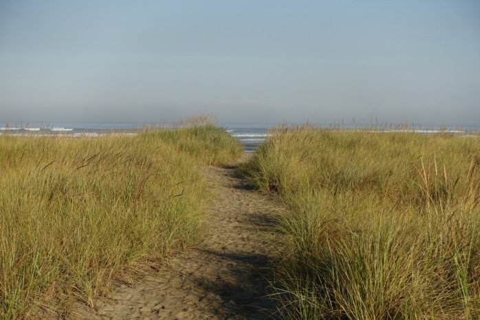

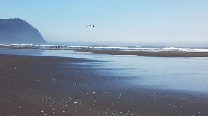
It does wonders for the soul.
– Susanne
Happy Two Years with Benji
“Hey Benji! Do you know what today is?”
“No, what??” he asked.

“Two years ago we brought you home from Seattle Humane to live with us – and I’m so glad we did! You’re the best cat ever!”
“Aw, really Sue? I bet you say that to all your cats.”

“No really Benji. I mean it. You’re something special. Whatever you do,

you do it with such style and enthusiasm, you give cats everywhere a good name.”

“Isn’t that right Tiger?”

“Oh never mind. Happy Two years Benji!”

“Thanks Sue.”
~ Susanne and Benji and Tiger
Remembering the Hoh Rain Forest

As we eagerly wait for rain to clear the smoky skies, it seems like a good time to remember a beautiful place where rain is king – the Hoh Rain Forest. Just four hours west of Seattle in Olympic National Park, it’s one of the best examples of temperate rain forest in the world and averages 12 – 14 feet of rain per year! We camped there recently, rain-free, next to the Hoh River and walked the trails through the rain forest.

The upper story is composed of conifers many over 200 feet tall, primarily Sitka Spruce, Western Hemlock and Douglas Fir. That’s me standing in front of a giant Sitka Spruce.

The lower story consists of Vine Maples and Big Leaf Maples draped in moss, and of course lots of ferns. The pictures below were taken on the Hall of Mosses Trail and include Bob, my husband and tour guide.


As beautiful as the trees are, I wouldn’t want to be lost in these woods at night, where they might wake up and grab unsuspecting hikers!

After the Hall of Mosses, we took the Spruce Trail through a younger section of the forest,

and passed by Taft Creek which sparkled in the sunlight.


Eventually we reached the banks of the Hoh River and paused to enjoy its raw beauty.

It was a wonderful visit though too short, and honestly a bit too crowded on the trails during the busy summer months. I’d love to return to the Hoh again, perhaps in late spring or fall when rain is falling and the mosses are dripping wet. Or maybe I’m a bit crazy for rain after our hot, dry, and smoky summer. Maybe both.
~ Susanne
Fun with Blogging, Computers and Ergonomics
When I say ‘fun’ I mean the blogging part, the actual creative writing and posting of pictures, thoughts and other fancies; the technical computer issues and ergonomics, not so much. First let me tell you that for years I got paid to sit at a desk with one or more computers on it, my little fingers working away at those keyboards most of the day and for the most part, pain-free. If I had technical issues with my desktop I could call the Help Desk, and if I had issues with my workspace I could call upon the Safety experts and they would evaluate the desk, chair, keyboard, whatever, until it was ‘ergonomically’ correct.
Now I blog at home and alas there is no one to call upon for these issues. So recently when I became uncomfortable at my desk I decided it was time for a new chair. And since my computer kept freezing up – it was 6 years old, ancient in computer years – I replaced it too.
Sounds simple enough, right? Sure, uh-huh.
First the chair. The old one wasn’t working anymore. I couldn’t sit long without lower back pain so off we went to buy the most comfortable chair in the store. ‘In the store’ – these are the operative words for unfortunately it doesn’t work so well with my desk at home. My husband will likely keep the new chair to replace his ancient one – which I am now using as I type this. I still seek a new chair. And maybe a new desk too. (It’s the domino effect folks, and it’s starting to get expensive.)
Second the computer. I had forgotten about the hassles of dismantling the old one and setting up the new. And the joy of sifting through billions of pictures to save and transfer. Yes, thanks to digital cameras I take five times as many pictures as I need, most of which I will never look at again and save them in files on my computer. And no I don’t use the cloud, whatever exactly that is. Lesson learned I guess.
Don’t mean to complain here, but I’m anxious to get back to blogging in a comfortable environment, sharing with you pictures of my favorite cats and travels too, pain-free. In the meantime Benji has tested the new computer and finds it ergonomically to his satisfaction, especially when using his feet. I admit I haven’t tried that yet.

Do my fellow bloggers have these issues? Or are you all sitting comfortably on your sofa, feet up, blogging on your laptop or phone? If so, I envy you.
~ Susanne
Tiger ~ a day in the life
Before there was Benji, Tiger had the place to himself; here’s his story of a typical day in paradise.
